Google Maps marker getting placed in wrong place
Categories:
Troubleshooting Google Maps Markers Appearing in the Wrong Location
Learn common causes and solutions for Google Maps markers being placed inaccurately, ensuring your map displays data correctly.
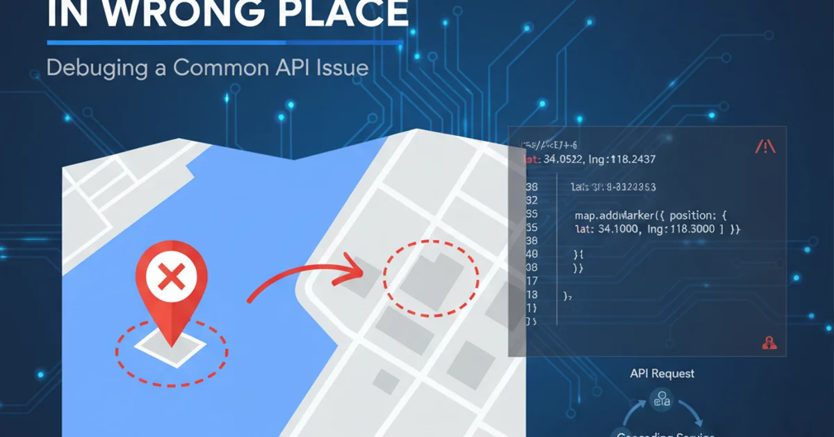
Google Maps is a powerful tool for displaying geographical data, but sometimes markers don't appear exactly where you expect them to. This can lead to confusion for users and misrepresentation of data. This article will explore the most common reasons why Google Maps markers might be placed incorrectly and provide practical solutions to resolve these issues, focusing on the Google Maps JavaScript API v3.
Understanding Marker Placement Fundamentals
At its core, a Google Maps marker is positioned using a LatLng object, which represents a geographical point with latitude and longitude coordinates. The accuracy of your marker's placement directly depends on the precision and correctness of these coordinates. Any discrepancy in the LatLng values, whether due to data entry errors, incorrect geocoding, or coordinate system misunderstandings, will result in misplaced markers.
flowchart TD
    A[Start] --> B{Obtain LatLng Coordinates}
    B --> C{Are Coordinates Accurate?}
    C -->|No| D[Identify Source of Error]
    D --> D1[Data Entry Error]
    D --> D2[Incorrect Geocoding]
    D --> D3[Coordinate System Mismatch]
    D --> E{Correct Coordinates}
    C -->|Yes| F[Create google.maps.LatLng Object]
    F --> G[Create google.maps.Marker]
    G --> H[Set Marker Position]
    H --> I[Add Marker to Map]
    I --> J[Marker Displayed Correctly]
    E --> F
Flowchart illustrating the process of placing a Google Maps marker and potential error points.
Common Causes for Misplaced Markers
Several factors can contribute to markers appearing in the wrong location. Identifying the root cause is the first step towards a solution. Here are the most frequent culprits:
1. Incorrect Latitude and Longitude Data
The most straightforward reason for a misplaced marker is incorrect LatLng data. This could be due to manual data entry errors, issues with your data source, or problems during data transformation. Latitude values range from -90 to +90, and longitude values from -180 to +180. Swapping these values or using out-of-range numbers will lead to wildly incorrect placements.
var map;
function initMap() {
  map = new google.maps.Map(document.getElementById('map'), {
    center: {lat: -34.397, lng: 150.644},
    zoom: 8
  });

  // Correct coordinates for Sydney Opera House
  var correctLatLng = {lat: -33.8568, lng: 151.2153};
  var correctMarker = new google.maps.Marker({
    position: correctLatLng,
    map: map,
    title: 'Sydney Opera House (Correct)'
  });

  // Incorrect coordinates (e.g., swapped lat/lng or typo)
  var incorrectLatLng = {lat: 151.2153, lng: -33.8568}; // Swapped
  var incorrectMarker = new google.maps.Marker({
    position: incorrectLatLng,
    map: map,
    title: 'Sydney Opera House (Incorrect - Swapped)'
  });

  // Another incorrect example (e.g., typo in longitude)
  var anotherIncorrectLatLng = {lat: -33.8568, lng: 51.2153}; // Typo
  var anotherIncorrectMarker = new google.maps.Marker({
    position: anotherIncorrectLatLng,
    map: map,
    title: 'Sydney Opera House (Incorrect - Typo)'
  });
}
Example demonstrating correct vs. incorrect LatLng usage for marker placement.
2. Geocoding Issues
If you're converting addresses to coordinates using the Google Maps Geocoding API or a similar service, the geocoding process itself can introduce inaccuracies. This might happen if the address is ambiguous, incomplete, or if the geocoder returns a less precise result (e.g., the center of a city instead of a specific building). Always check the location_type property in the Geocoding API response to understand the precision of the result.
location_type in a Geocoding API response can indicate precision: ROOFTOP is most precise, followed by RANGE_INTERPOLATED, GEOMETRIC_CENTER, and APPROXIMATE.3. Asynchronous Loading and Timing
When working with dynamic data or external APIs, timing can be crucial. If you attempt to place markers before the map object is fully initialized or before your LatLng data has been successfully fetched, markers might not appear at all, or they might appear at a default location (often 0,0 or the map's initial center) before being updated, causing a flicker or incorrect initial placement.
// Incorrect approach: Attempting to add marker before map is ready
// var map;
// function initMap() {
//   // map is not yet fully initialized here
//   addMarkerToMap(someLatLng);
//   map = new google.maps.Map(document.getElementById('map'), { /* ... */ });
// }

// Correct approach: Ensure map is ready before adding markers
var map;
function initMap() {
  map = new google.maps.Map(document.getElementById('map'), {
    center: {lat: -34.397, lng: 150.644},
    zoom: 8
  });

  // Simulate fetching data asynchronously
  setTimeout(function() {
    var dataLatLng = {lat: -33.8688, lng: 151.2093}; // Sydney
    var marker = new google.maps.Marker({
      position: dataLatLng,
      map: map,
      title: 'Dynamic Marker'
    });
    console.log('Marker added after map initialization and data fetch.');
  }, 1000);
}
Demonstrating the importance of asynchronous loading and ensuring the map is ready before placing markers.
4. Coordinate System Differences (Less Common for Google Maps API)
While less common with the Google Maps API (which primarily uses WGS84 coordinates), if you're importing coordinates from other systems (e.g., local projections, older GPS devices), there might be a mismatch in coordinate systems. Ensure all coordinates are in the standard WGS84 format (latitude, longitude) that Google Maps expects.
1. Verify LatLng Data
Manually check the latitude and longitude values for accuracy. Use an online tool (like Google Maps itself) to plot the coordinates and confirm they point to the intended location.
2. Inspect Geocoding Responses
If using a geocoding service, examine the full API response. Pay close attention to the location_type and formatted_address to ensure the geocoder returned a precise and correct result for your input address.
3. Ensure Map Initialization
Make sure your google.maps.Map object is fully initialized before attempting to create or set the position of any markers. Use callbacks or promises for asynchronous data loading.
4. Check for Swapped Coordinates
It's a common mistake to swap latitude and longitude. Remember: LatLng objects expect latitude first, then longitude.
5. Debug with Console Logs
Use console.log() to output the LatLng values just before creating the marker. This helps confirm that the values being passed to the google.maps.Marker constructor are what you expect.